Advanced Remote Sensing Technologies for Environmental Monitoring
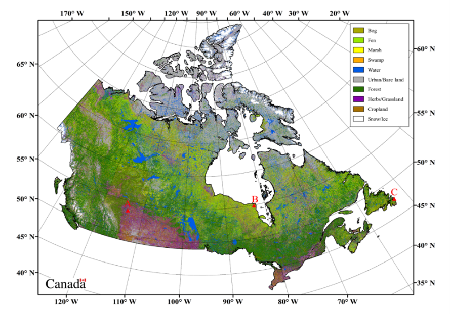
Salehi-Geolab led by Dr Bahram Salehi at SUNY is an active research lab with multiple PhD, MSc, and BSc students conducting research in monitoring the environment at various scales from national level to state, regional and landscape levels. We combine multi-sensor space borne synthetic aperture radar (SAR), multispectral, and lidar as well use unmanned aerial vehicle (UAV) data through advanced machine/deep learning to study various ecosystems. In this talk, I will present a quick summary of our research and findings in three primary areas including nation-wide wetland monitoring, state-wide forest biomass and carbon, inland freshwater water quality monitoring, and detailed 3D forest modelling using satellite, airborne and UAV-based earth observation data. Our project areas include regions in the U.S, Canada, and Latin America.
Date and Time
Location
Hosts
Registration
-
 Add Event to Calendar
Loading virtual attendance info...
- Center for Image Science
- 54 Lomb Memorial Drive
- Rochester, New York
- United States 14623
- Building: 76
- Click here for Map
Speakers
 Bahram Salehi of SUNY ESF
Advanced Remote Sensing Technologies for Environmental Monitoring
Salehi-Geolab led by Dr Bahram Salehi at SUNY is an active research lab with multiple PhD, MSc, and BSc students conducting research in monitoring the environment at various scales from national level to state, regional and landscape levels. We combine multi-sensor space borne synthetic aperture radar (SAR), multispectral, and lidar as well use unmanned aerial vehicle (UAV) data through advanced machine/deep learning to study various ecosystems. In this talk, I will present a quick summary of our research and findings in three primary areas including nation-wide wetland monitoring, state-wide forest biomass and carbon, inland freshwater water quality monitoring, and detailed 3D forest modelling using satellite, airborne and UAV-based earth observation data. Our project areas include regions in the U.S, Canada, and Latin America
Biography:
Dr. Salehi has over 19 years of academic and industrial R&D experience in geospatial engineering and remote sensing in the U.S and Canada. His research areas include machine learning and applications development of multispectral, synthetic aperture radar (SAR), and UAV data for environment monitoring with focus on wetland, forest, and water quality mapping and change monitoring. He is the co-author of over 60 peer-reviewed journal papers and book chapters with more than 3000 citations and a Google Scholar h-index of 30 as of October 2022. He has many years of teaching experience in remote sensing (optical/ SAR), photogrammetry and UAV, machine learning as well as surveying and geomatics engineering in three universities in Canada and the U.S. Since 2014, Bahram has been the principal supervisor (major professor) of 1 post-doctoral fellow, 8 PhD students, 3 MSc students, and several undergraduate and intern students. Bahram is a recipient of a number of awards including the 2019 early career achievement medal from the Canadian Remote Sensing Society. He is a licensed member of Canadian Professional Engineer (P.Eng), a licensed project management professional (PMP), and a senior member of IEEE (SM. IEEE).
Email:
Address:State University of New York (SUNY) College of Environmental Science and Forestry (ESF), 416 Baker Hall, 1 Forestry Dr., Syracuse, New York, United States, 13210