Automatic generation of 3D building models
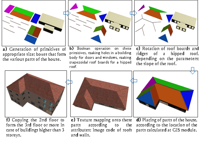
A 3D urban model is an important information infrastructure that can be utilized in several fields, such as, urban planning and game industries. However, enormous time and effort have to be spent to create 3D urban models, using 3D modeling software such as 3ds Max or SketchUp. In our research we will employ automatic generation of 3D building models through integrating GIS (Geographic Information System) and CG (Computer Graphics). An integrated system is proposed for automatically creating 3D building models from building polygons (building footprints) on a digital map. Since most building polygons’ edges meet at a right angle (orthogonal polygon), a complicated orthogonal building polygon can be partitioned into a set of rectangles. The integrated system partitions orthogonal building polygons into a set of rectangles and places rectangular roofs and box-shaped building bodies on these rectangles. This proposal seeks to implement a novel approach to 3D building model construction for rapid assessment of roof damage and insurance liability in the aftermath of natural disasters.
The research will achieve two objectives:
- The integration of GIS and 3DCG (3D Computer Graphics) components in a new extension for the ArcGIS platform that generates both simple and complex 3D house models from building footprints (building polygons).
- Automated generation of simple and complex roof geometries for rapid roof area damage reporting by length measurements and area calculations of all roof surfaces. In addition to the application to the assessment of roof damage, this system can be applied to BIM (Building information modelling: 3d building model whose parts are linked to each attribute, and by which collision detection between parts can be made).
Date and Time
Location
Hosts
Registration
-
 Add Event to Calendar
- 1000 KLO Rd
- Kelowna, British Columbia
- Canada V1Y 4X8
- Building: E
- Room Number: 103
- Contact Event Host
- Co-sponsored by Okanagan College
- Starts 16 March 2017 11:00 AM UTC
- Ends 21 March 2017 12:00 AM UTC
- No Admission Charge
Speakers
 Dr. Kenichi Sugihara of Gifu Keizai University in Gifu Pref. Japan
Biography:
Dr. Kenichi Sugihara, Professor (Doctor of Engineering) of Gifu Keizai University in Gifu Pref. Japan. Kenichi graduated from the graduate school of Nagoya University in 1979 and in 2001. He was working at Panasonic for 7 years and at Sony for 3 years as an built-in micro-computer engineer. He specialized in computer science in CG and GIS and in automatic generation of 3-D urban models by the integration of GIS and CG based on digital maps. He has started studying of civil engineering, specifically urban planning and disaster prevention, where computer science is of great use, especially CG and GIS. The research in engineering and urban planning provides him government subsidies additionally.
Email:
Address:Gifu, Japan
Dr. Kenichi Sugihara of Gifu Keizai University in Gifu Pref. Japan
Biography:
Email:
Address:Gifu, Japan