Surface Current Maps Retrieved from Drone Based Video
This presentation introduces CopterCurrents, a cost-effective method for mapping surface currents using drone-based video analysis. Utilizing an off-the-shelf drone equipped with a standard visible-light camera, CopterCurrents extracts surface current data by analyzing wave properties—such as wavelength, propagation direction, and speed—through the dispersion relation of ocean waves.
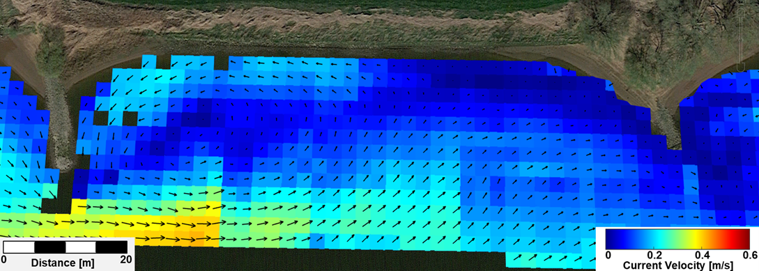
Field measurements conducted in diverse environments will demonstrate the method’s capabilities and limitations. Additionally, results from a validation experiment in a tidal estuary will be presented. In this study, video sequences were captured using a quadcopter with a downward-facing camera, while concurrent current data were collected using a shallow-water Acoustic Doppler Current Profiler (ADCP) mounted on an autonomous surface vehicle. Over a full tidal cycle, current speeds varied between 0 and 1 m/s, with complex flow structures, including eddies. The comparison between CopterCurrents and ADCP measurements showed a strong correlation (0.95), a root mean square error of 0.06 m/s, and a bias of -0.01 m/s.
Unlike ADCPs, drone-based measurements provide rapid spatial coverage, high temporal resolution (up to 30 s), and the ability to monitor dynamic flow patterns over hazardous or shallow water areas. These advantages make CopterCurrents a valuable tool for efficient surface current mapping in challenging environments.
Date and Time
Location
Hosts
Registration
-
 Add Event to Calendar
- Townsville, Queensland
- Australia 4814
- Building: 509
- Room Number: To be advised
- Starts 16 July 2025 02:00 PM UTC
- Ends 13 August 2025 12:00 AM UTC
- No Admission Charge
Speakers
Jochen of Helmholtz-Zentrum Hereon, Germany
Surface Current Maps Retrieved from Drone Based Video
Biography:
Jochen Horstmann received the Diploma in physical oceanography (Dipl.-Oz.) and the Ph.D. in earth sciences (Dr. rer. nat.) from the University of Hamburg, Germany, in 1997 and 2002, respectively. He was with GKSS Research Center, Geesthacht, Germany, where he joined the Coupled Model Systems group in 1995 and has been a Research Scientist with the Institute for Coastal Research since 2002. Since 2007 he has also been an Adjunct Professor of the Division of Applied Physics and the Department of Ocean Sciences of the Rosenstiel School of Marine and Atmospheric Science, University of Miami, USA.
In 2002, he was a Visiting Scientist with the Applied Physics Laboratory of the John Hopkins University, Laurel, MD, and with the National Environmental Satellite, Data, and Information Service from NOAA, Washington, DC. In 2004 and 2005, he was a Visiting Scientist with the Center for Southeastern Tropical Advanced Remote Sensing of the University of Miami, FL. From 2008 to 2013, he was a Senior Remote Sensing Scientist with Nato Undersea Research Center in La Spezia, Italy. Since 2013 he is head of the department of Radar Hydrography in the Institute of Coastal Ocean Dynamics at the Helmholtz-Zentrum Hereon, Germany.
He has a wide experience in the field of ocean radar remote sensing (SAR, Marine Radar, HF-Radar) and signal processing and has published over 90 scientific papers in international peer-reviewed journals. His main research interests are the development of applications for radar and video-based sensors with particular focus on ocean surface and near surface processes.
Address:Germany